
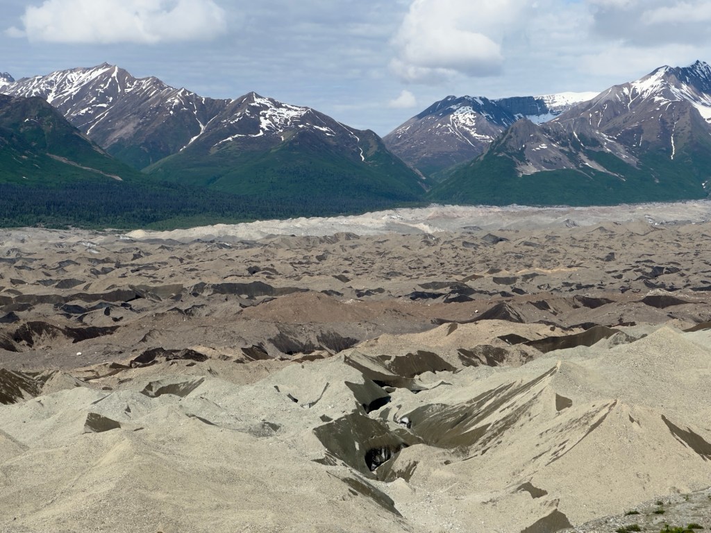
If the Kennecott Mill represented the bright percussive rhythm of a song, the glaciers around the mill were the underlying drumbeat; a steady, subtle, ever present reminder of the conditions surrounding this town. Visually, what you see is not a quintessential bright white glacier with pools of electric blue reflected back from the sun, but rather a wide river of dirt, sand, gravel and rock that looked like its roaring wave action had been paused, suspended in time.
We have been lucky enough to walk on the Mantauska Glacier, boat to the Northwestern glacier and watch it calve, hike to a view point over looking the Franz Joseph glacier, but the Kennicott Glacier (not a typo – the glacier is spelled with an “i”, the town with an “e” – don’t get me started on that…it was several glasses of wine before I could sort that out), kept me captivated for days as I tried to wrap my head around what I was looking at. Wrangell-St. Elias National Park has the largest concentration of glaciers in North America; 33% of the park is covered by glacier ice.
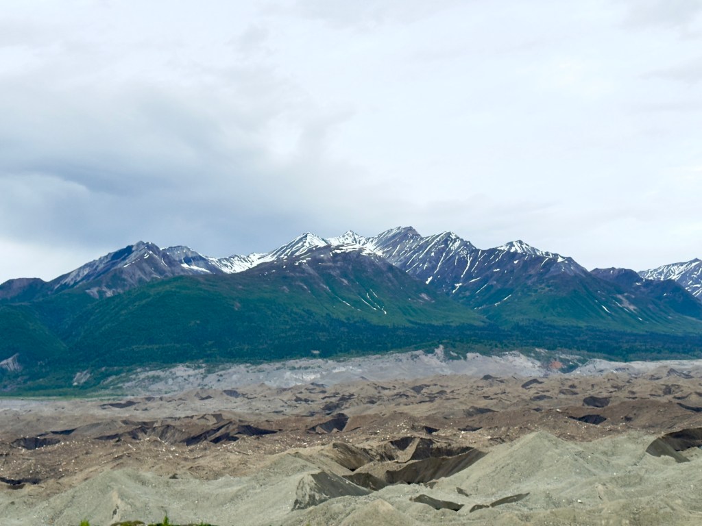
The shuttle driver told us that many visitors mistake the river of dirt as tailings from the mining operations, but really it is a 2 foot thick layer of material the glacier has bulldozed and collected on its journey down from the mountaintop.
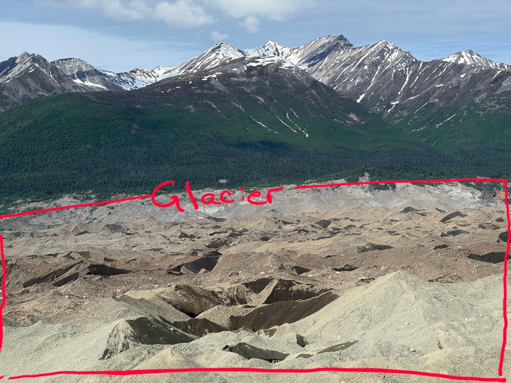
But it’s not quite like a bulldozer. Instead of just piling up stuff and pushing it all in front, the glacier is also scraping up earth from underneath it. Quite a bit of this stuff finds its way to the top of the glacier, and makes it look “dirty”. It also doesn’t help, that toward the end of the glacier, less fresh snow gets accumulated and compacted so ice no longer forms. As it gets thinner, the glacier stops moving, the ice melts, and all the stuff it’s been collecting is left in place. The are three zones to a glacier: The accumulation zone is up high where new ice is being created, the ablation zone is in the middle where heat causes the ice to melt, and the “rotting” terminus toward the end is where the ice is concealed below a layer of debris. What I was looking at was miles and miles of terminus.
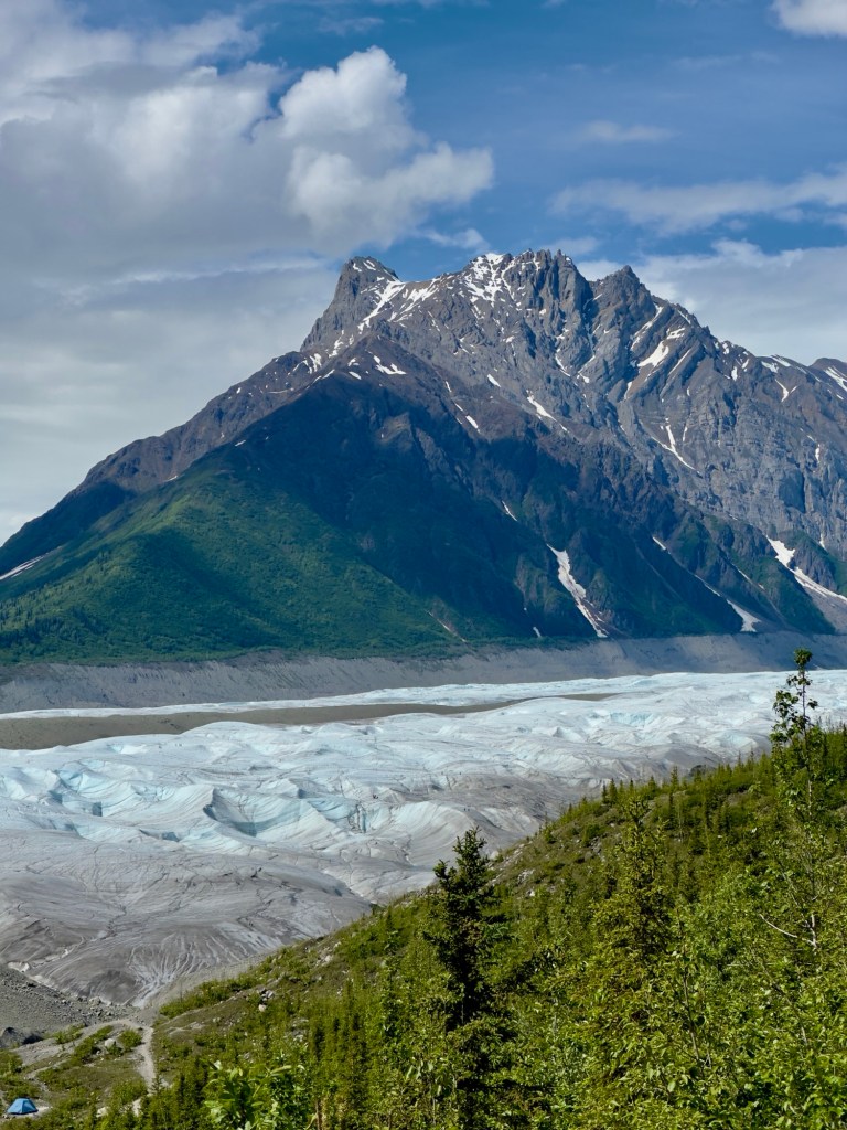
What is really mind boggling, is that less than 100 years ago, this glacier was so tall and thick, it blocked the view of the mountains. All you saw was a wall of dirty ice towering over you. Today, as you stand on the patio of the lodge, two stories higher than the main road, you look down on a wall of ice that is anywhere from 800-1,200 feet deep covered in about 2 feet of “dirty ice”.
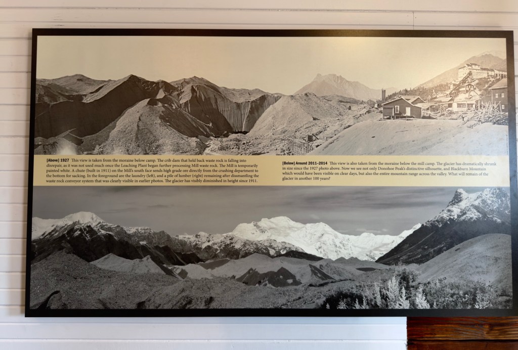
That is what you see today. In 1938, the glacier was 1,200-1,800 feet deep. Imagine, finishing a hard day of work in the mill and staring out at a wall of ice and dirt 1,800 feet high…right in front of you. That is about the height of the One World Trade Center in New York, and it would have been 27 miles long and 3 miles wide.
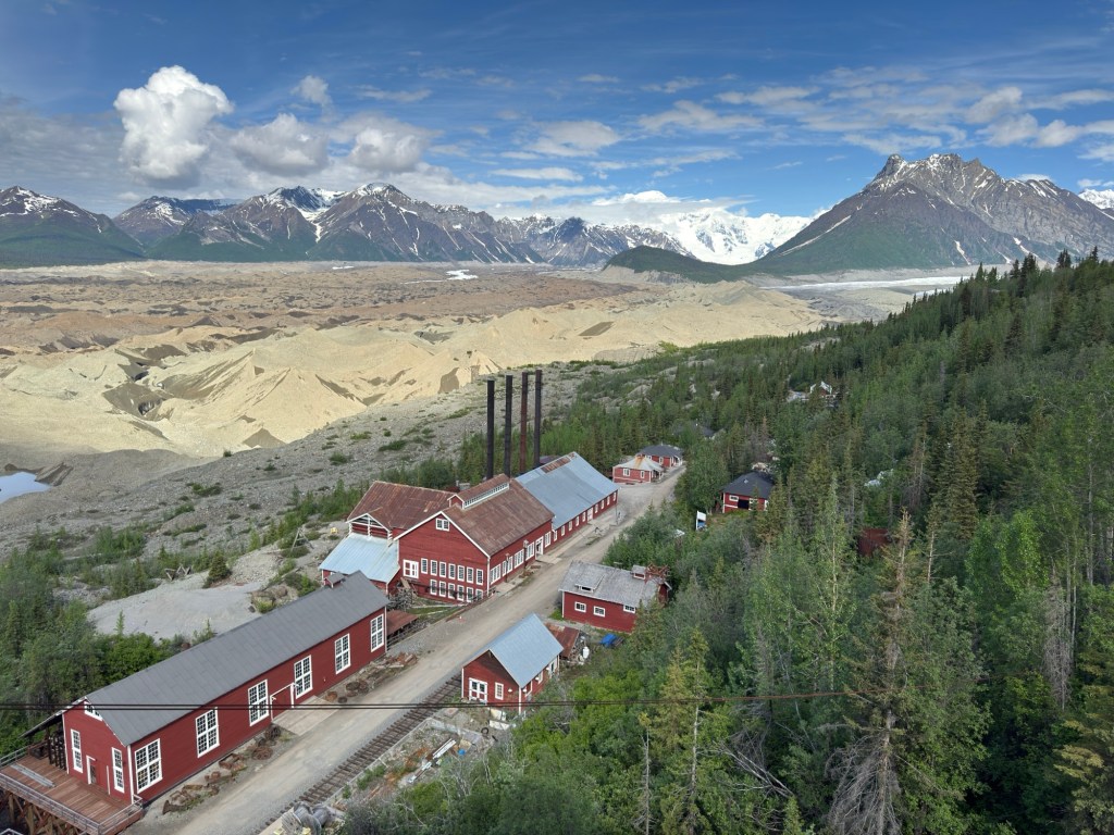
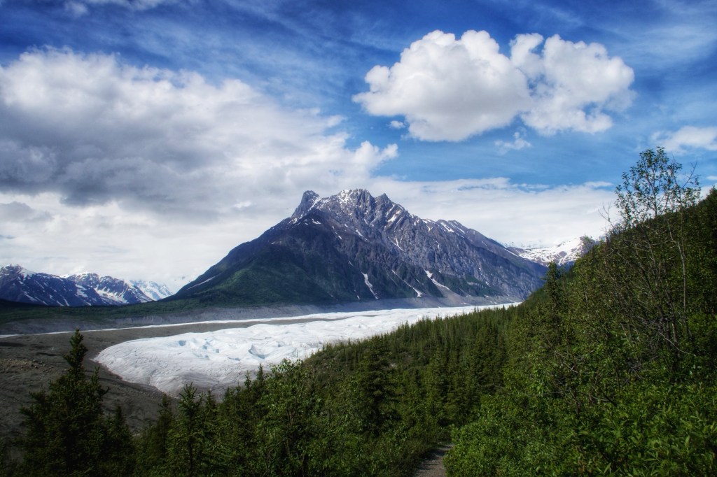
In the valley, as you look out from the mill, two glaciers converge to your right at the base of the mountains, the Kennicott and Root Glaciers.
You can hike a couple of miles up to the Root Glacier, strap on a pair of crampons, and walk on the ice. The Root Glacier hosts the Stairway Icefall, which is the second largest icefall in the world (Everest has the the most famous, but not the largest), and the largest icefall in the world outside of the Himalayas. We hiked to a viewpoint overlooking the Root Glacier, but since we forgot our crampons (Ruh-roh), and it was hot (yes, we had an unusually hot day), we decided to turn around and commence happy hour early. I had to share that last bit, because donning crampons makes me sound like a bad a**, even though it would have taken a village to get me out there on that ice, and get me off in one piece. On our hike, we did see a lot of moose poop. I was grateful for Cat’s lesson, because I deduced it was all winter poop and felt optimistic that a moose encounter of the scary kind would not be in the cards for me.
On a side note, I have coined a new phrase, “Alaska fish face”… it’s the face that true blue Alaskans make when they eat a piece of fish that has not been cooked properly (translation: The fish has not been prepared and presented in a semi-raw state, somewhere between sushi grade and medium rare).

Leave a comment